Author Archives: Glenn Kellogg

Buffalo, NY: Mains Street Streetcar Analysis- TIGER Grant Applications

Buffalo streetcar

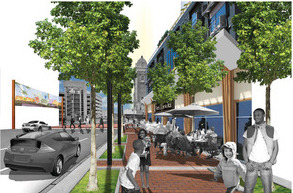
Urban Advisors worked on a team with Highland Planning, Bergman Associates, and DiDonato Associates to submit a successful 2011, TIGER III grant application for infrastructure and street improvements along the existing downtown Buffalo streetcar corridor. This complete streets project will reintroduce two-way vehicle traffic to Main Street in downtown Buffalo, NY and improve existing transit stations along the Main Street and fund major streetscape improvements to revitalize and reorient economic growth downtown — part of a larger initiative to revitalize the historic downtown by improving transportation connectivity, reinvesting in streetscaping, and encouraging retail growth. Urban Advisors conducted the benefit/cost analysis, quantifying the impacts of improvements. Analysis included evaluation of land productivity based on rents and residual land value, residual value of right of way improvements, construction and long term employment, retail spending and reduction in injury. Our team carefully considered the aspects of each benefit and advanced successful arguments for the advantages of the streetcar corridor improvements. The City received a $15 million grant for the project, have bid for construction of the first block, and are awaiting permission to proceed.  The team worked again successful bids for TIGER V and TIGER VII funding, most recently securing an $18 million grant in 2015.

Petaluma, CA: SMART Station Area TOD Planning and Code

petalima cover crop

Urban Advisors participated with Opticos Design in planning two SMART rail station areas for the City of Petaluma. We provided local and regional market information for housing, retail, and employment uses to begin the process and then worked with the public and the design team during a charrette to develop site programs and determine preliminary feasibility. The resulting scenarios were used to provide a basis for creating a form based code for the station areas and to assist in updating the current code for downtown Petaluma.

Cincinnati, OH: Form Based Code

Charter2014_announcement-wide-2-opt-670x382
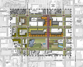
Urban Advisors assisted Opticos Design and GlazerWorks Architects in the creation of a form based code for four Cincinnati neighborhoods. Urban Advisors was tasked with ensuring the economic viability of recommendations in the code for each neighborhood and developing economic development strategies for neighborhood housing, employment and business with implications for physical development that would then be addressed in the code. The project has been considered a success and the code was approved this year. In addition, neighborhoods are moving ahead with plans for redevelopment with the assistance of the city economic development department based upon the work performed by the team.

Omaha, Nebraska: Federal District Neighborhood Housing & Development Study

fed dist

Graphics by H3 Studio

Fed dist plan


Developers and land owners in downtown Omaha took responsibility for coordinating development in their neighborhood and sponsored this study to engage the public and plan for the future of the Federal District. Working with H3 Studio, Urban Advisors assisted with stakeholder engagement and a public planning process that articulated a vision for the district. Our analysis provided insight to downtown business sizes and space requirements that together with employment projections demonstrated likely future demand for employment space by firm size. Demographic analysis and projections helped understand the demand for housing preferences in the area and described demand for a variety of products in walkable downtown neighborhoods. An important consideration in this neighborhood was developing “Whole Places” that offer housing for all incomes, ages and lifestyles with access to neighborhood services and employment. The resulting plan provides a strategy for essential public improvements that will allow new growth and private development in a safe, vibrant, inclusive and pedestrian friendly environment. Key concepts detailed new public spaces as well as a new main street and traffic configuration creating the hart of the community.

Beaufort County, SC: Form Based Code

Beaufort

Urban Advisors was retained to assist Opticos Design in the development of an economically viable vision as a basis for a form based code for Beaufort County, SC. Through analysis of local employment and demographic trends and pro forma financial testing of alternatives in collaboration with the design team, the code was developed and included the following goals: freeing land from access restrictions that prevent development; repairing non-conforming conditions with coding that recognizes past patterns as a guide to the future while maintaining historic character; providing tools for preserving self-determining communities that enable change over time without undue expense; increasing land use efficiency in a way that enables landowners to realize greater profit on land held while also creating needed development and services in a way that benefits the community; and, increasing the flexibility of use to enable developers to respond to market conditions.

El Paso, TX: Plan El Paso – Economic Analysis & Development Strategy

PlanElPasoBanner

Plan El Paso is the new comprehensive plan for the City of El Paso, Texas. Urban Advisors worked with a team led by Dover Kohl & Partners on a two year process that included three public charrettes. Using a combination of demographic data and projections, geographic information systems data for the City and over twenty neighborhoods, Urban Advisors identified goals for development intensity, created transit oriented development scenarios and formed economic development strategies to assist the City in achieving its goal of complete places and complete streets. Plan El Paso won the 2011 National Award for Smart Growth Achievement and the 2012 Texas Chapter of the American Planning Association Comprehensive Planning Award.

St. Louis County, MO: Jamestown Mall- Economic Analysis & Development Strategy

Jamestown

Urban Advisors worked with Dover Kohl & Partners and H3 Studio on a redevelopment plan that balances the interests of the community, property owners, developers and the County.  Since the opening of the mall on the outer fringe of the St. Louis metro area in 1973, the shopping center has been declining. The neighbors were left feeling abandoned and underserved, making this revitalization project a priority for the County.  Urban Advisors explained the underlying causes of decline, and determined a feasible development strategy to create a walkable environment with a mix of land uses that provides on-site support for the desired local retail services. The plan envisions a community that provides opportunities for families to live in a walkable village, close to shops and employment, and sets a vision for a high quality of design and construction.  At the conclusion of the process, the County was actively engaged with the land owners and the adopted plan won the Outstanding Planning Award from the Missouri Chapter of the American Planning Association.

Washington, DC: TOD Station Area Analysis & Typology

DCTOD

Working with Nelson Nygaard, TND Planning, and DC Office of Planning Staff, Urban Advisors helped in developing a typology of 35 Metro Station Areas.  Urban Advisors has been developing analysis tools for understanding the potential of places to change under the formative effects of planning.  Looking at 35 station areas, we used GIS analysis to identify the capacity of station areas for new development based on existing zoning.  The analysis first identified how much land was either vacant, or under-improved.  Under-improvement was evaluated based on the projected value of total build-out of each tax parcel under current zoning, compared with the actual tax assessments.  This removed the price of land from the analysis, which eliminated factors such as neighborhood and locational values allowing us to compare different neighborhoods around the city.  Next, the net capacity for development under the same categories of existing improvement value were calculated to understand the capacity for new development in the station areas.  This innovative analysis technique is proving useful in helping policy makers classify Station Areas by existing potential and land utilization, so that appropriate policy tools and zoning can be applied to shape the vision for each area.

Overland Park, KS: Form Based Code Economic Analysis

Overland Park FBC

Our team, led by Ferrell Madden Lewis, was charged with developing a Form Based Code for downtown Overland Park and two neighborhood nodes.  This project implemented the Vision Metcalf corridor plan, promising a new direction for the City, championing sustainability, walkability and pedestrian places.  After assisting with the balance of supportable land uses at each node, we worked with the design team to evaluate the feasibility of proposed site plans based on a typical lot size for each district, parking configurations and financial analysis.  Using GIS analysis of land and building values, we then described the potential economic impact of redevelopment under the new code.  One of the design ideas included creating a new street where land is now mostly vacant.  Pro-forma analysis of redevelopment scenarios for this site demonstrated the importance this infrastructure improvement could have for the downtown as a catalyst project.

Michigan City, Indiana: TOD Economic Impact Analysis

Michigan City Areas

Michigan City retained Economic Visions, TND Planning Group, and Urban Advisors to evaluate the economic development potential around three alternative commuter rail stations.  The commuter line is required to make safety changes to its track, opening the opportunity to relocate the line and build a new station and with it transit oriented development.  Our team was asked to comment on three alternative alignments and determine the potential economic impacts of each for the downtown.  Our conclusions outlined the potential economic benefits of each location, while acknowledging the political and implementation constraints.  This study succeeded in building consensus for choosing an alignment, and at the final presentation the regional rail authority publicly announced support for the recommended station area configuration and development.